


le tour des lacs de carli

mouss65
User
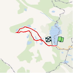

Length
11.4 km

Max alt
2372 m

Uphill gradient
398 m
Km-Effort
16.6 km

Min alt
2004 m

Downhill gradient
364 m
Boucle
No
Creation date :
2014-12-10 00:00:00.0
Updated on :
2014-12-10 00:00:00.0
3h51
Difficulty : Medium

FREE GPS app for hiking
 SityTrail
IGN / Geographical institutes
SityTrail Plus
The world is yours!
About
Trail Walking of 11.4 km to be discovered at Occitania, Pyrénées-Orientales, Les Angles. This trail is proposed by mouss65.
Photos


Positioning
Country:
France
Region :
Occitania
Department/Province :
Pyrénées-Orientales
Municipality :
Les Angles
Location:
Unknown
Start:(Dec)
Start:(UTM)
418039 ; 4712453 (31T) N.
Comments

